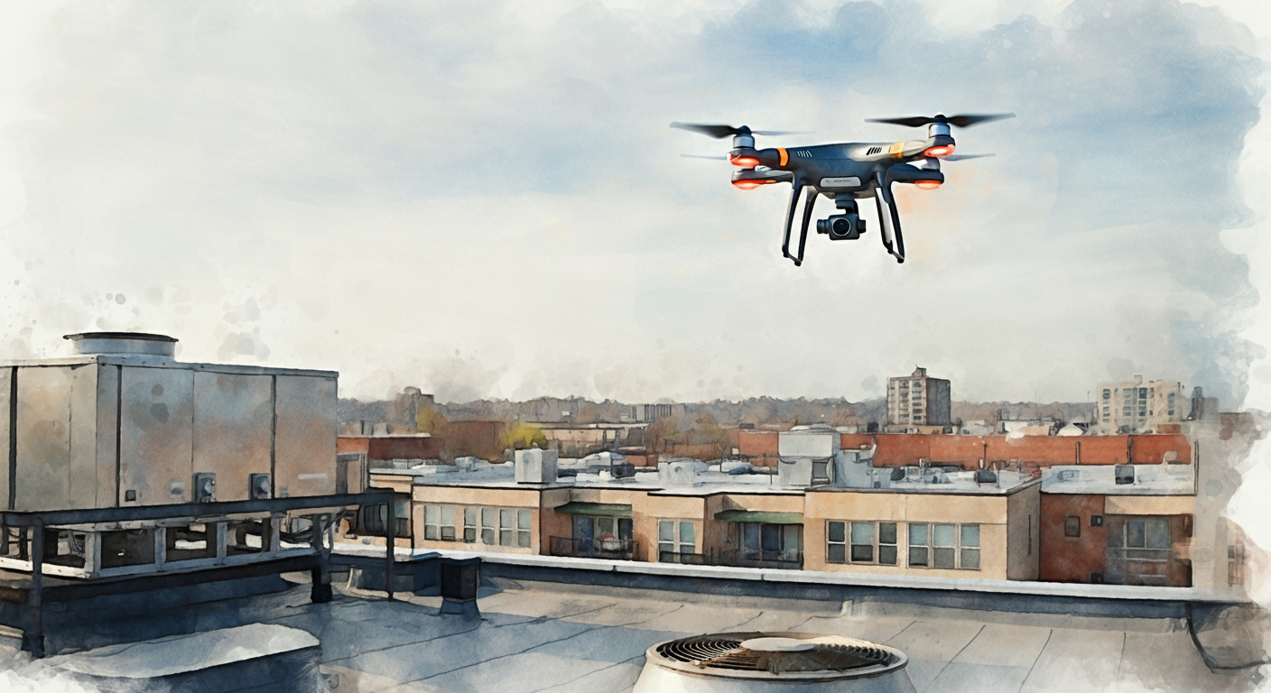
Drones in commercial real estate have moved well beyond marketing photography. Powered by the FAA’s Part 107 rule and rapid advances in sensors and AI, leading owners and operators now use drones for roof and façade inspections, parking-lot asset planning, thermal loss detection, stormwater monitoring, construction progress verification, and high‑fidelity digital twins.
Adoption is still far from mainstream, but capabilities, costs, and regulatory clarity are converging. The next pivotal shift—the FAA’s proposed Part 108 rule—is expected to unlock remote operations and help scale more fleets nationwide.
In this Insights by Blueprint report, we explore how drones are reshaping commercial real estate, from their growing role in asset inspections to the advantages of outsourcing drone services to upcoming FAA regulations that could expand capabilities even further. We’ll draw on results of our latest Advisory Council survey to detail how top real estate operators are using drones today.
The turning point for drones in CRE
The passage of FAA Part 107 in 2016 marked the single most impactful shift for drones in commercial real estate. By creating a clear licensing pathway for commercial drone pilots, the rule reduced regulatory ambiguity and dramatically lowered barriers to entry.
“Drones give you the aerial perspective that once required cranes, helicopters, or airplanes, options that were prohibitively expensive for most real estate owners,” says Tombo Jones, Director of the Mid-Atlantic Partnership at Virginia Tech, an FAA-designated UAS test site. “The 2016 FAA Part 107 rule changed everything, making those capabilities accessible and practical at scale.”
FAA’s Part 107 opened the door to greater drone use in real estate aerial photography. But as drone technology has advanced, so have applications in commercial real estate. Drone hardware has progressed along a steep innovation curve while costs continue to decline.
Most early drone models carried only RGB (Red, Green, and Blue) cameras. It’s the same type of camera you’d have on your smartphone.
Today, advanced drone models are routinely equipped with:
- Thermal sensors for energy-efficiency assessments
- Multispectral (NDVI) sensors for vegetation and landscape health
- LiDAR systems for precise 3D mapping and volumetric analysis
These capabilities are expanding the range of applications and are becoming more accessible. Advanced sensors are dropping in price by 10% to 25% year over year, even as resolution, accuracy, and ease of deployment improve.
Equally important has been the software revolution. AI-powered platforms can now ingest vast streams of drone-supplied data and automate workflows that once required days of manual review.
Together, these advances have redefined the drone’s role. They are no longer mere supplementary tools for marketing images or occasional inspections. Instead, drones serve as integral nodes in a digital inspection and asset management ecosystem.
High‑value drone use cases
Drones are increasingly used to conduct inspections across building systems, exterior structures, and site infrastructure, offering property teams safer, faster, and more data-rich alternatives to traditional methods.
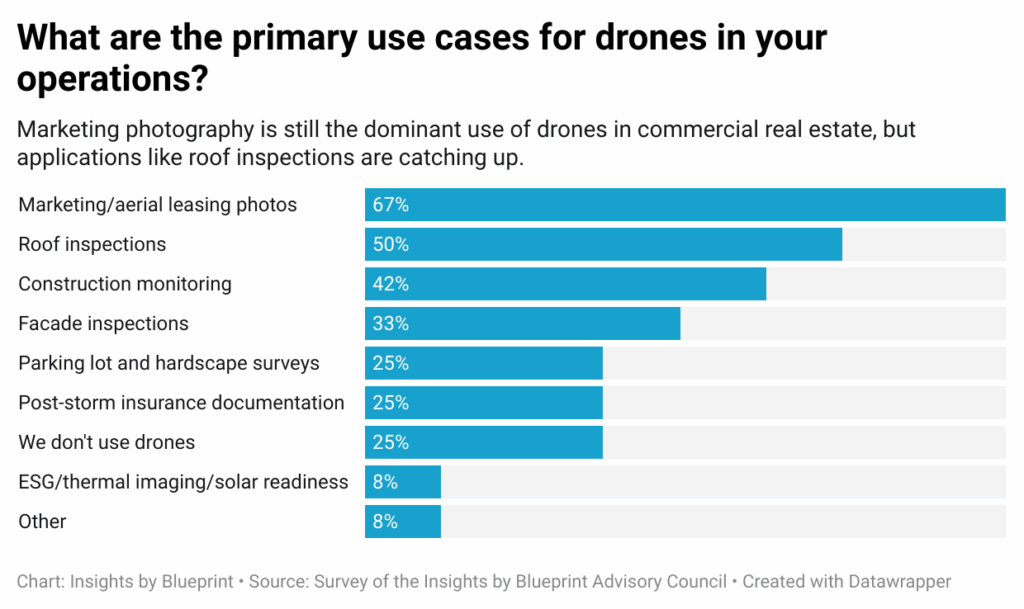
Roughly 42% of CRE operators on the Insights by Blueprint Advisory Council report using drones as a routine part of their portfolio operations, while another 17% say their use is limited to select assets or pilot programs.
Marketing and aerial leasing photography remains the dominant use case (67%). But operators also use drones for roof inspections (50%), construction monitoring (42%), and facade inspections (33%).
Roof and HVAC inspections are among the most beneficial drone use cases in commercial real estate. Drones can capture detailed imagery of roofing materials, providing insights into material condition, patching history, and signs of ponding.
Beyond surface assessments, drones can also create a census of rooftop HVAC units, recording counts along with make, model, and serial numbers, while checking for corrosion or drainage issues.
With thermal sensors, they can identify trapped moisture below membranes or pinpoint hot and cold anomalies that indicate energy inefficiencies or failing equipment.
Façade and envelope inspections also benefit significantly from drones. Multi-story exterior scans can now be performed safely and efficiently using both visual and thermal imaging. In many cases, this eliminates the need for costly and risky rope descent systems. Repeat drone flights enable change detection over time, providing a clear record of how façades evolve and where issues may be emerging.
For parking lots and hardscape, drones can fly lawnmower-style ortho-mosaic patterns, stitching the results into high-resolution maps. These maps allow operators to track crack growth, measure pothole expansion, and monitor striping condition over time. About 25% of CRE operators on the Insights by Blueprint Advisory Council report utilizing drones for parking lot and hardscape condition surveys.
By quantifying surface degradation, owners can build predictive maintenance models and evaluate the cost impact of immediate versus deferred repair. Drones also assist with broader asset planning by mapping stall counts, ADA compliance zones, and EV charging or solar placement opportunities.
In stormwater and green infrastructure management, drones verify drainage paths, inspect retention ponds, and spot vegetation overgrowth that could block inlets or compromise flow. They can also perform surface-area measurements to ensure that properties meet code-required green space thresholds.
How to make the business case
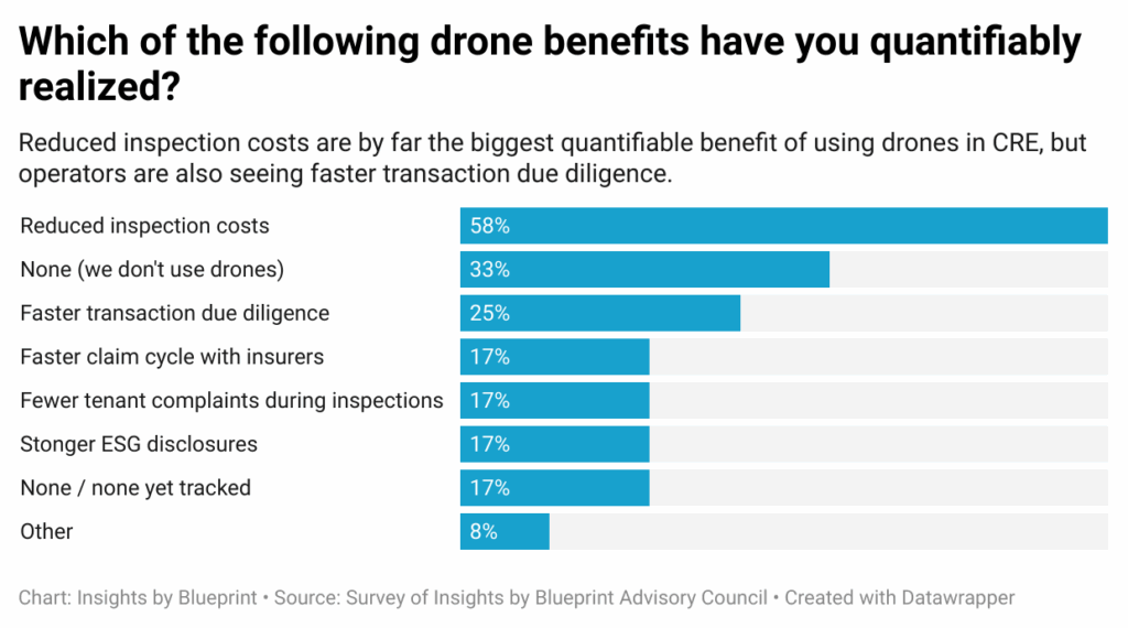
The challenge for many CRE operators is convincing owners that drones are useful and worth the cost. As one operator from the Insights by Blueprint Advisory Council tells us, “There are plenty of use cases and clear value during due diligence, but it’s harder to quantify that value during the hold period. The real challenge is tying drone use directly to ROI over the course of ownership.”
The true value of drone inspections lies in linking their outputs directly to avoided costs, risk reduction, and measurable energy savings. When owners quantify these impacts, drones shift from being a novelty to a core part of asset management.
For most real estate operators, property maintenance tends to be reactive. Repairs are made when something fails, not necessarily when it’s most cost-effective.
“There’s a lot of waste that goes into it when a real estate owner is doing work on a property,” says Austin Rabine, CEO of SITE Technologies. SITE Technologies is a company that turns high-resolution exterior imagery and AI-powered analysis into actionable asset-condition intelligence for commercial property portfolios. “A property manager might make a decision, but they don’t really understand why they’re doing it or why they need to fix it, or they’re not fixing it at the right time.”
This timing and understanding gap is precisely what predictive inspection and analytics platforms aim to address. “You’re never managing a property to be in perfect brand-new condition,” Rabine says. “Nobody has the budget for that, and it doesn’t make sense. The way a building deteriorates is that it’s slow for a while, but at a certain point, it starts to deteriorate exponentially.”
The implications are clear when you look at the numbers. If an operator can identify repair needs early, “you might spend $2 a square foot to repair that pavement,” Rabine explains. “In three years, if you don’t catch it, it could cost you $8 a square foot.” By catching issues at the optimal time, owners avoid major capital expenditures and extend asset life.
SITE Technologies’ platform helps visualize this tradeoff directly. “We’ve built tools that show, if you don’t do this project this year, this is what it’s going to cost you next year, this is what it’s going to cost you in two years,” Rabine says.
With this data, operators can make more informed decisions about when to execute repairs, taking budget, timing, and long-term ROI into account. “A customer might say, ‘Yes, I want to do this now,’ or ‘I’m willing to pay a little more next year because I don’t have the budget today,” Rabine explains.
The risk of going DIY with drones
Many organizations begin their drone journey the same way. They purchase between $2,000 and $25,000 in hardware, assign a staff member to oversee the program, and assume it is ready to go.
But almost immediately, the hidden complexities start to appear.
To operate legally and safely, companies need airspace authorizations, waivers for certain operations, detailed operational manuals, and specialized sensors for different use cases. Maintenance schedules must be managed, data pipelines must be built to convert imagery into usable formats, and, critically, aviation insurance must be secured.
The pace of hardware obsolescence only compounds the challenge. New drone technology improvements and sensor upgrades tend to make investments outdated within 12 to 24 months.
“CFOs hate hearing this, but if you buy a drone today, it’ll be a paperweight in a few years,” says Dacoda Batels, COO for FlyGuys. This drone services company acts as a platform connecting businesses with a network of licensed drone pilots. “I’ve got hundreds of paperweights outside my office that aren’t even two years old.”
This is where specialized vendors provide clear advantages. Their fluency in regulations allows them to navigate waivers, near-airport operations, and controlled airspace without burdening an in-house team.
They also carry the liability through aviation insurance, often with policies that reach $10 million, transferring significant risk away from the property owner or operator. Vendors can right-size the cadence of drone captures—monthly, quarterly, or biannually—so the output aligns with KPIs rather than ad hoc site visits.
The risks of attempting a DIY approach are not theoretical.
“About five years ago, a commercial real estate office told us they didn’t need our services because someone in-house had a drone,” says Sheri Painter, Co-Founder of Birds Eye Aerial Drones. This San Diego–based drone services provider specializes in commercial and industrial applications. “That drone ended up crashing and causing about $3 million in damage, which immediately triggered a National Transportation Safety Board investigation.”
Painter continued, “Most people don’t realize that if a drone crash causes just $500 in damage, it has to be reported. After that incident, the broker came back to us and said, ‘Maybe we should be using your drones instead of our own.’”
Drone vendors are not the only ones who say outsourcing drone services makes the most sense. “Some companies do build their own drone departments, but it takes a huge investment, and flying over neighborhoods and people carries real risks,” says Tombo Jones of the Mid-Atlantic Partnership.
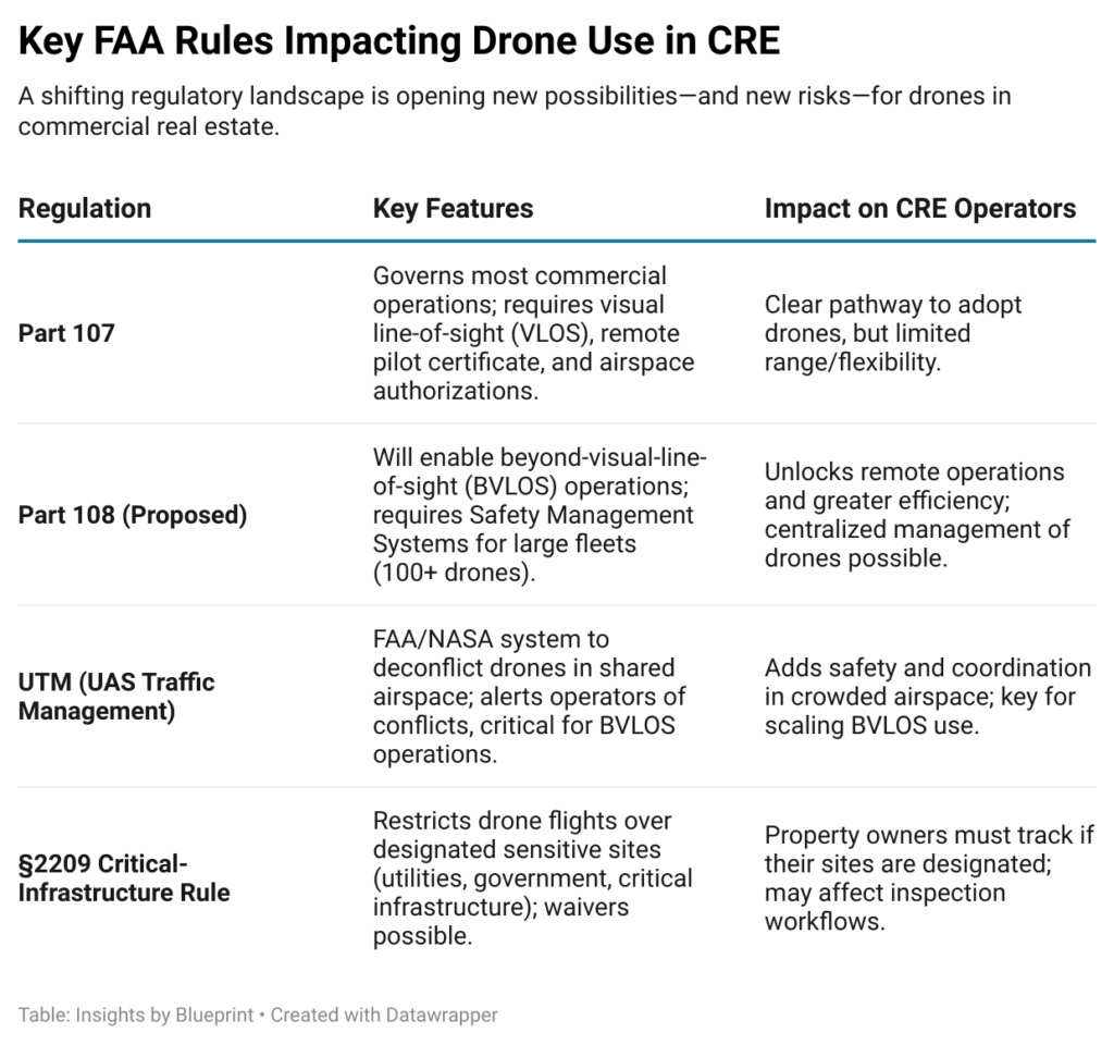
Part 108 and the future of drones in CRE
The current regulatory framework for drones in the U.S. is defined primarily by the FAA’s Part 107, which governs most commercial operations today. Under this rule, drone pilots must maintain a visual line of sight (VLOS) with their aircraft at all times.
Operators must hold a remote pilot certificate and obtain additional airspace authorizations when flying in controlled areas. This has created a clear pathway for companies to adopt drone technology, but it also imposes limitations on how far and how flexibly drones can be deployed.
Looking ahead, the proposed FAA Part 108 rule represents the next major shift. This regulation is expected to enable beyond-visual-line-of-sight (BVLOS) operations at scale, unlocking far greater efficiency and flexibility. However, it will also come with heightened requirements, most notably the implementation of Safety Management Systems for larger fleets, likely those operating 100 or more aircraft.
When finalized, Part 108 will pave the way for remote operations in which centralized pilots can manage drones across multiple sites simultaneously, rather than sending staff into the field for each individual flight.
“The upcoming Part 108 rule may open the door for operators to remotely manage drones, even across state lines,” says Dacoda Bartels of FlyGuys. “That’s a huge leap in efficiency and potential applications.”
Another key piece of the regulatory landscape is UTM, or UAS Traffic Management. Originally a NASA concept, now being trialed by the FAA, UTM is designed to safely deconflict drones in shared airspace.
“The software alerts us if there’s a conflict with another drone in the air,” says Tombo Jones of the Mid-Atlantic Partnership. “That’s especially critical for beyond-visual-line-of-sight operations, where you need advanced systems to detect and avoid conflicts you can’t see directly.”
A related development to watch is the forthcoming §2209 Critical-Infrastructure Rule, which will formalize restrictions on drone flights over certain designated facilities such as utilities, government buildings, and other sensitive sites.
The rulemaking is expected to allow waivers or carve-outs in some cases, but property owners will need to pay close attention, particularly if their assets could fall into these categories. Commenting during the rulemaking process will be important for ensuring industry perspectives are heard.
The practical takeaway is that property owners and operators don’t need to become regulatory experts themselves, but they do need to understand enough to make informed decisions.
The smartest approach is to work with partners who already have deep expertise in navigating these rules, while keeping a strategic eye on how regulatory changes could affect inspection cadence, vendor choice, and long-term asset management strategies.
Mapping the CRE drone vendor landscape
The drone vendor landscape is diverse.
Some companies offer nationwide pilot networks geared toward convenience and marketing, while others emphasize enterprise-grade analytics, specialized enclosure inspections, or media-focused storytelling. Still others are pushing drones into the realm of standardized asset intelligence and capital planning.
Understanding the distinctions is critical for CRE decision-makers weighing cost, scalability, and integration. The following vendor profiles highlight key players across this spectrum, showing how their capabilities align with different needs in inspections, monitoring, marketing, and long-term portfolio management.
Keep in mind: this list is not meant to be exhaustive.
An estimated 300 to 500 drone vendors nationwide actively serve CRE clients, ranging from sole proprietors to national networks. Only about 20 to 50 firms have the scale and operational maturity to support institutional owners and multi-state portfolios.
The majority are regional or local providers suited for smaller projects. For CRE operators, this highlights a fragmented vendor landscape with many options but few that can consistently deliver standardized data and coverage across large portfolios.
Dronegenuity
Dronegenuity provides nationwide drone services for real estate, construction, and energy clients through a network of vetted pilots.
The company’s offerings include aerial photography and video for property marketing, mapping and 3D modeling for construction projects, and inspection services, including roof assessments, thermal imaging, and solar-site documentation. It also operates a training division offering online courses and FAA Part 107 exam preparation, while recruiting and certifying independent pilots to expand its network.
Founded and led by CEO Dan Edmonson, the company emphasizes accessibility, consistency, and affordability across markets. Reviews commonly highlight ease of use and competitive pricing, though—as with many network-based models—service consistency can vary depending on local pilot availability.
For commercial real estate operators, Dronegenuity offers a cost-effective outsourced model well-suited for marketing, inspections, and construction progress documentation across multiple markets.
Blueprint’s take:
Dronegenuity shows the strengths and weaknesses of an outsourced drone model. Its nationwide pilot network makes it easy for CRE owners to access services without investing in equipment or in-house staff. For marketing and basic documentation, the service is cost-effective and convenient.
But reliance on independent pilots raises concerns about consistency and quality control, with some reports of payment and communication issues. For operators, Dronegenuity is best suited as a scalable, entry-level solution rather than as a partner for specialized applications such as LiDAR or complex asset management.
DroneDeploy
Founded in 2013 and headquartered in San Francisco, DroneDeploy has developed into a leading enterprise software platform for drone-based reality capture. Its software supports flight planning, photogrammetry, high-accuracy mapping, 3D models, and analytics of aerial imagery.
In 2022, DroneDeploy acquired StructionSite to unify aerial, 360° camera, and ground-based capture workflows. In February 2021, the company raised $50 million Series E funding round, bringing its total capital raised to ~$142 million at that time.
DroneDeploy serves thousands of organizations across many countries and is widely used in construction, energy, inspection, and surveying applications. For commercial real-estate operators managing large portfolios, the platform offers value in site documentation, progress monitoring, and inspection
But realizing full value typically depends on established workflows, integration with asset management systems, and organizational alignment.
Blueprint’s take:
DroneDeploy has emerged as the clear enterprise leader in drone-based reality capture, especially after expanding into ground robotics with its StructionSite acquisition.
For CRE operators, it offers a rare combination of scale, accuracy, and integration, turning visual data into actionable insight across the asset lifecycle. The platform excels at site documentation and progress monitoring, making it a strong fit for multi-site portfolios.
Its sophistication is also its hurdle. Realizing full value requires investment in internal workflows, training, or partnerships. But for organizations ready to operationalize drone data, DroneDeploy sets the benchmark.
Structura View
Structura View is a building-enclosure consulting firm based in Lakeland, Florida, specializing in inspection and testing of commercial roofs, walls, and façades.
Through a combination of drone aerial imaging and on-roof/moisture-mapping technologies, the firm produces detailed condition reports geared toward property owners, managers, insurers, and contractors.
While the company’s footprint is strongest in Florida (Lakeland, Orlando, Tampa, Miami), its marketing materials indicate capability throughout the state, and it presents itself in a way that would allow expansion beyond Florida.
Its service offering is particularly applicable for CRE owners/operators with significant roof or façade exposure where water intrusion or envelope deterioration is a concern. By blending advanced diagnostics with consulting and reporting, Structura View positions itself distinctly among firms that offer only basic drone imagery.
Blueprint’s take:
Structura View represents a highly specialized slice of the drone vendor ecosystem: building-enclosure inspections. Its strength lies in blending drone technology with traditional testing to produce deliverables directly useful to CRE decision-makers facing roof and facade risks.
Unlike national drone networks, it is not a broad, all-purpose solution. Its niche is roofs, moisture, and envelope performance. For portfolios concentrated in the Southeast, or any operator looking to benchmark enclosure condition, Structura View provides depth over breadth. The trade-off is scalability. While it claims national reach, its Florida base suggests the strongest reliability and responsiveness in regional markets.
VidTech

VidTech is a drone and visual media company based in Thousand Oaks, California, focused on the commercial real estate market.
The firm’s service suite includes drone photography and video, 3-D modeling/virtual tours, and a branded inspection/monitoring offering called “Vidspections.” Inspection packages begin at approximately $499.
Their asset-class coverage spans retail, industrial, multifamily, office, land, and development sites, and their pricing for marketing-video “Videom” packages goes up to around $2,999. VidTech positions itself as both a marketing partner and an inspection/monitoring vendor.
The company advertises coverage across many U.S. markets and emphasizes standardized deliverables, making it a strong fit for brokers, property managers, and owners who need visual content and monitoring services at scale.
Blueprint’s take:
VidTech is less about deep geospatial analytics and more about turning drone data into polished, market-ready content for CRE. Its “Vidspections” and video packages show a clear emphasis on visualization, leasing, and storytelling rather than technical mapping.
That makes it a strong fit for owners and brokers who need consistent, professional imagery across multiple markets at transparent prices. The trade-off is sophistication. VidTech won’t replace a platform like DroneDeploy for construction analytics or asset modeling. But for marketing, inspections, and standardized visuals across a CRE portfolio, it’s a pragmatic, media-focused solution.
Birds Eye Aerial Drones
Birds Eye Aerial Drones, LLC (BEAD) is a Service-Disabled Veteran-Owned Small Business (SDVOSB) based in El Cajon, California, founded by Navy veteran Scott Painter in 2014.
The firm offers drone-based imagery, mapping, GIS/orthomosaic services, and consulting work across infrastructure, utilities, rail/roads, and commercial real estate sectors. BEAD’s commercial real estate relevant services include aerial photography and videography, site and land-use mapping, and condition-assessment flights of property exteriors.
While its strongest known base is in Southern California, the company advertises its willingness to deploy nationwide and emphasizes turnkey aerial-data solutions. For CRE owners or operators seeking both visual content and geospatial/asset data capture, BEAD offers a versatile option, though prospective clients should verify regional coverage and CRE-specific precedent for portfolio-scale assignments.
Blueprint’s take:
Birds Eye Aerial Drones brings a blend of credibility, consulting expertise, and operational versatility. Its SDVOSB status and early FAA approvals give it a strong footing in regulated environments, while its GIS and infrastructure projects demonstrate technical capacity beyond typical drone photography shops.
For CRE operators, BEAD is well-suited to condition assessments, due diligence, and planning where geospatial accuracy matters as much as imagery. However, while it advertises nationwide reach, its strongest presence is regional, and enterprise portfolios should verify coverage and data integration.
SITE Technologies

SITE Technologies, headquartered in Chicago, is a property-intelligence platform that goes beyond pure drone services.
The firm combines high-resolution imagery captured via drones, aircraft, and satellites with AI/ML-driven analytics and cloud-based dashboards to assess assets such as roofs, pavements, façades, and landscapes. Its platform supports condition scoring, predictive budgeting, RFP creation, and multi-site capital planning workflows.
In September 2023, SITE closed a $10 million Series A funding round led by Prologis Ventures, signaling investor confidence in its growth trajectory. For CRE owners and operators managing large or distributed portfolios, SITE offers a standardized, data-centric approach to long-term asset-performance management.
Blueprint’s take:
SITE is pushing drones into the enterprise asset-management space. Instead of treating aerial data as imagery, SITE transforms it into condition indexes and capital-planning tools, essentially turning roofs and parking lots into data points on a dashboard.
This makes it especially relevant for large CRE portfolios where standardization and budget forecasting matter more than flashy visuals. The trade-off: SITE requires commitment to workflows and integration, and likely carries a higher cost than ad-hoc vendors. But for operators looking to professionalize exterior asset management at scale, SITE represents one of the most advanced, CRE-specific platforms on the market.
The next frontier in aerial intelligence
One of the most intriguing trends in the drone sector today is the emergence of drone data marketplaces. This new business model could redefine how aerial imagery is captured, shared, and monetized.
Traditionally, commercial property data has been sourced from manned aircraft or satellite imagery, often updated infrequently and limited to major metropolitan areas. That model is changing. As Austin Rabine of SITE Technologies explains, new players are now deploying fleets of drones to systematically capture vast geographic areas and then archive that imagery for sale across multiple industries.
“It’s not necessarily new technology,” Rabine says, “it’s just kind of a new model. They’re going out and capturing large areas with drones, archiving that data, and selling it to different markets.”
In effect, these firms are building a nationwide database of high-resolution drone imagery, similar to how companies once flew aircraft to collect aerial data for resale to real estate developers, agricultural producers, and government agencies. The difference lies in scale, quality, and cost.
“It’s a giant database of drone imagery,” Rabine says. “Today, you can get imagery from a satellite anywhere in the world, or from a manned aircraft in major U.S. markets. But now there’s a company doing that with drones, and the imagery is better than a manned aircraft or satellite, obviously.”
Because drones can fly lower and slower, they capture richer visual detail than satellite or airplane sensors. At the same time, the rapid growth of certified drone pilots and advances in automation make it increasingly affordable to gather this data across broad regions.
Rabine believes this “Google Maps on steroids” model could significantly reduce the cost of data capture for commercial real estate operators. Instead of commissioning a one-off flight for each property, firms may soon be able to purchase archived, high-resolution drone imagery on demand and integrate it into their asset-management or inspection workflows.
CRE’s eyes in the sky
Drones remain a valuable tool for aerial photography and marketing in commercial real estate, but their role has expanded far beyond visuals. For forward-looking CRE operators, drones are evolving into indispensable instruments for inspections, progress monitoring, and data-driven asset intelligence. Today, they can deliver insights that improve safety, reduce costs, and support smarter portfolio management.
The vendor ecosystem remains fragmented, with hundreds of providers but only a small set capable of delivering portfolio-level scale and standardization. The choice comes down to fit: convenience-focused networks, enterprise-grade platforms, specialized consultants, or media-centric providers.
With FAA Part 108 on the horizon, the next evolution may be remote operations and scalable fleets. Owners who start aligning drone use with measurable ROI today will be best positioned to capitalize on this shift in the years ahead.
– Nick Pipitone